
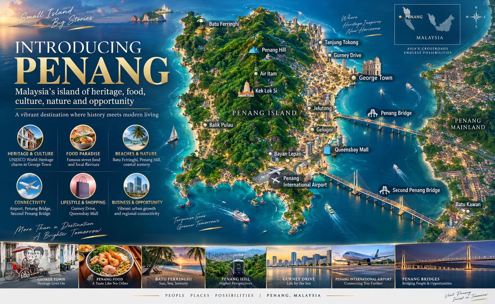
WHY PENANG?
One state.
Two connected shores.
Penang brings heritage, food, beaches and modern city life together with an international airport, established healthcare and education networks, and major industrial corridors across Penang Island and Seberang Perai.
CURRENT INDICATORS
Signals that shape Penang’s geography
These figures describe the state’s operating context. They do not forecast property prices or returns.
Airport passenger movements, 2024
Penang’s business-events guide also reports 415,058 passenger movements through Swettenham Pier Cruise Terminal in 2024.
PCEB source ↗Penang E&E exports, 2024
InvestPenang reports this represented 60% of Malaysia’s E&E exports.
InvestPenang source ↗Healthcare travellers to Malaysia, 2024
MHTC lists Loh Guan Lye, Island Hospital and Gleneagles Penang among its Penang member hospitals.
MHTC source ↗INDUSTRY
Island and mainland production corridors
Bayan Lepas anchors Penang’s mature E&E cluster. Batu Kawan and Bandar Cassia extend advanced manufacturing and related services on the mainland. InvestPenang reports RM22.4 billion in total manufacturing investment value for 2025.
Review InvestPenang data ↗TOURISM & HERITAGE
A living heritage city with regional reach
George Town has been part of the UNESCO World Heritage listing with Melaka since 2008. The recognised city is part of a broader tourism landscape spanning food, culture, beaches, nature and business events.
UNESCO listing ↗HEALTH & EDUCATION
Services used across daily life
Private hospitals, universities and international schools are distributed across George Town, Tanjung Bungah, Bayan Lepas, Balik Pulau and mainland growth areas. The location matters because daily travel patterns differ sharply between island and mainland.
LANGUAGE & CULTURE
Multilingual in everyday practice
Bahasa Malaysia, English, Mandarin, Tamil and Penang Hokkien are widely encountered. UNESCO describes George Town’s built and living heritage as shaped by Malay, Chinese, Indian and European influences.
PLANNED CONNECTIVITY
Mutiara Line LRT at a glance
The current official plan describes 29.67 km of elevated viaduct, 22 stations and two provisional stations, including a sea crossing between Macallum and Penang Sentral. The map on the New Launches page shows a schematic route for geographic context.
View projects with map layers ↗Silicon IslandAirportBayan LepasMacallumKomtarPenang Sentral
Official Mutiara Line information ↗PENANG QUESTIONS
Quick answers for readers and search assistants
Where is Penang in Malaysia?
Penang is on the northwest coast of Peninsular Malaysia. The state combines Penang Island, including George Town and Bayan Lepas, with mainland Seberang Perai, including Butterworth and Batu Kawan.
Why is Penang associated with semiconductors?
Penang has a long-established electrical and electronics ecosystem across Bayan Lepas and mainland industrial corridors. InvestPenang reports that Penang produced RM358.1 billion of E&E exports in 2024, equal to 60% of Malaysia’s E&E exports.
How important are tourism and healthcare travel to Penang?
Penang combines heritage, food, beaches, business events and private healthcare. Penang International Airport recorded 7,473,462 passenger movements in 2024, while Malaysia welcomed 1.6 million healthcare travellers that year.
What languages are commonly used in Penang?
Bahasa Malaysia is the national language, while English, Mandarin, Tamil and Penang Hokkien are also commonly encountered. Language use varies by setting and community.
What will the Mutiara Line LRT connect?
The official plan describes a 29.67 km elevated alignment with 22 stations plus two provisional stations, linking Silicon Island through Bayan Lepas and George Town, with a sea crossing from Macallum to Penang Sentral.
What should a property buyer compare across Penang?
Compare the exact site, district, daily routes, flood and slope context where relevant, title and permitted use, maintenance costs, layout, completion timing and access to employment, education, healthcare and transport.